
Real-Edwards Conservation & Reclamation District
River Flows taken October 24, 2020
All river flow measurements were taken on Saturday, October 24, 2020. Our crossings have seen quite an irregular fluctuation in flow this year due to random rainfall, and heat and usage from the summer months. All river crossings have gravel, rocks and debris clogging several pipes. According to Water Weekly published by Texas Water Development Board (TWDB), from November 9, 2020, about one-fifth of the state is abnormally dry and considered vulnerable to drought expansion in the coming weeks. The National Weather Service states that La Niña conditions are currently in place, favoring a warmer and drier weather pattern across the Lone Star State through winter and spring. La Ni ña typically lasts approximately 9 to 12 months. However, the onset of numerous extreme Texas droughts has been associated with a La Niña event, including the 1950s, 2006, and 2011 droughts.
REMINDER: Both Edwards and Real counties are in a Burn Ban as well as Stage 3 Drought status. Be aware of fire hazards as well as dropping water levels. And pray for relief!
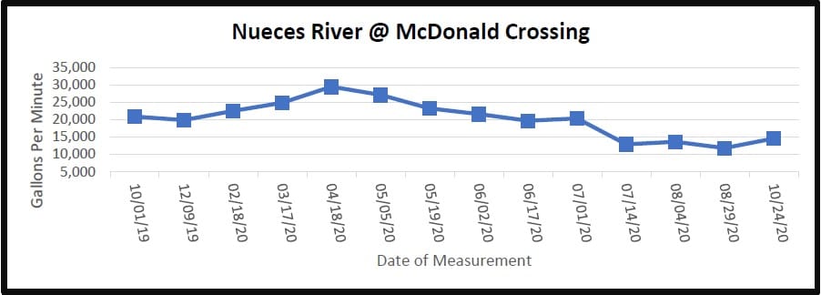
The Nueces River crossing at Highway 55 South of Camp Wood near the dam increased its flow from 20,559 gpm (gallons per minute) at last measurement (August 29, 2020) to a current reading of 25,804 gpm. The Nueces River at McDonald Road crossing slightly increased from 11,831 gpm in August to a current measurement of 14,564 gpm.
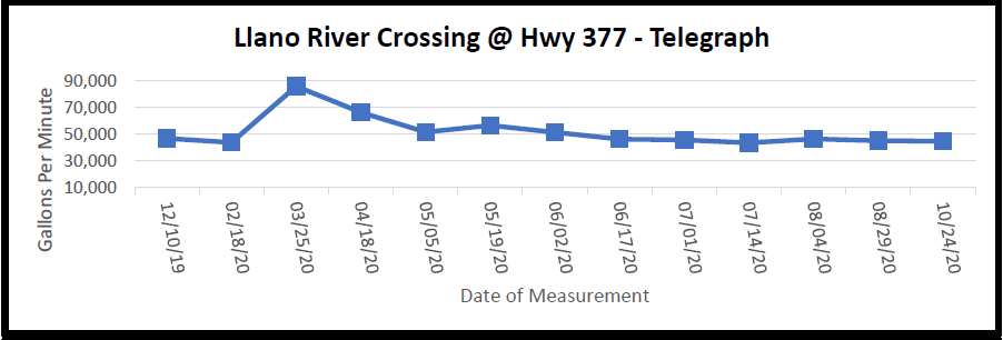
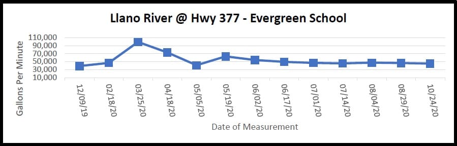
The South Llano River dips into northern Edwards County where it borders Kimble County and crosses Highway 377 twice. For the crossing at Telegraph, the South Llano measured a slight decreased flow of 44,663 gpm from the last measurement of 45,068 gpm. The Evergreen School crossing also slightly decreased to 45,213 gpm from the last measurement of 46,466 gpm.
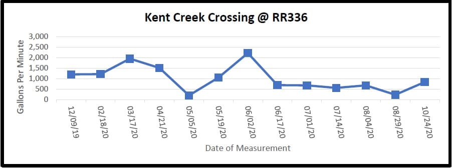
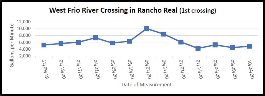
On Ranch Road 336 approximately 10 miles north of Leakey, Kent Creek crosses under the road and flows into the west prong of the Frio River. This crossing had an increased flow of 842 gpm from 235 gpm. Also, on RR336 is Rancho Real where the west prong of the Frio River twists and meanders. At the first crossing in Rancho Real, there was a slight increased flow of 4,843 gpm from last measurement of 4,456 gpm.
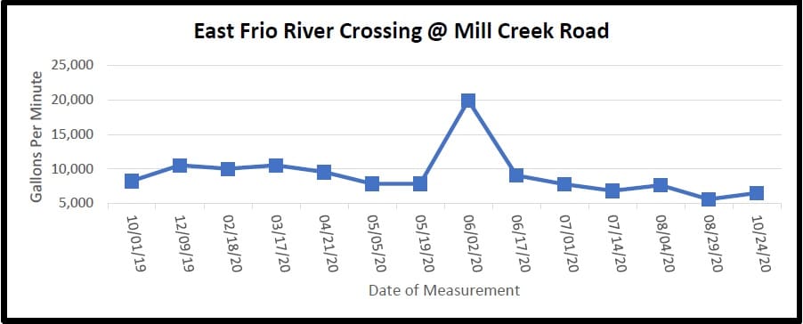
On U.S. Highway 83 north of Leakey, Mill Creek Road crosses the east prong of the Frio River before it merges with the west prong. This crossing showed an increased flow of 6,524 gpm from last measurement 5,611 gpm.
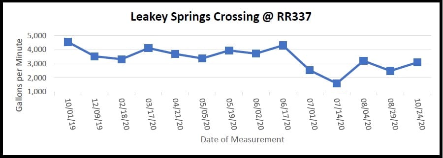
Following east on Ranch Road 337 and past the cemetery is the serene Leakey Springs tributary that flows into the Frio River. This crossing had measured a slight increase to 3,106 gpm from last measurement of 2,501 gpm.
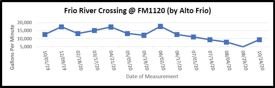
Traveling east on FM 1120 past the Alto Frio Baptist Encampment (also known as Fulgham’s Crossing), the flow increased from 4,939 gpm to a current flow of 9,389 gpm.